Summer officially started June 21st. But here in the Pacific Northwest, residents often live by the creed, "Summer actually starts on the 5th of July". It has been a decent start to the Summer here in Portland. A 80 degree day here or there. But even better news is showing up on the weather maps! Let's take a look.
Our first bit of evidence is the 500mb map. This is halfway up the atmosphere and shows us overall ridge (good) and trough (bad) patterns.
Here is the 500mb map valid last night for July 4th around 11 a.m. Look at the ridge that covers most of the West and extends all the way into northern Canada! This is a great set up for a nice stretch of warm, sunny conditions! Other maps re-enforce this fact.
The map above is our 850mb map. We use this map to locate areas of warm air and areas of cold air. We can track their movement with this map. The red contours on the map are isotherms, lines of constant temperature, in degrees Celsius. Temperatures at the 850mb level loosely translate to specific temperatures at the surface. This map, again valid last night (June 27th) shows the conditions for late morning on the 4th. The 15-degree isotherm is just to our east. If we estimate the 850 temp to be about 14 degrees Celsius above Portland, that would translate to an 80-degree day! Plenty of time for it to change, one way or another, but the warm temperature fits the above 500mb map we looked at! Here is your surface map for the Fourth of July! Looks awesome! Precipitation is nowhere to be seen. Also not the high pressure system out off the southern Oregon coast. That helps send any sort of wet systems well to our north! Any time we see surface pressure around 1020, that means good things. The 1020 isobar (lines of constant pressure) is right in our neighborhood. Average surface pressure is right around 1013. The higher the pressure, the better the conditions!
We have concluded our investigative work! Weather forecasting works like an investigation. Start with one map, and try to find validations on all the others. In our 4th of July case, things are lining up in a good way! Maybe this year, Summer in the NW starts early!
Many of you may not know who Arlene is. That's ok, she was overshadowed by some of her more famous sisters. She last showed up in June of 2005. She came to the Southern U.S. from Honduras and killed a person. She was the first of her kind that year, many others followed and did far worse things.
Of course I am talking about Tropical Storm Arlene. She made landfall about 6 years ago to the date. For a tropical storm, she was a large one. Just missing hurricane status. But she ushered in one of the most active and historic hurricane seasons on record! Her more famous sisters are known as Hurricane Katrina and Hurricane Rita. There were 26 named storms in 2005, so many that we ran out of names and had to use names from the Greek alphabet for the remaining storms.
2011 tropical season is underway, it began June 1st. So far, the Atlantic basin has been quiet. But forecasters have warned that it will not remain that way as the season progresses. The Climate Prediction Center says the Atlantic will see 12-18 named storms, 6-10 of which may reach hurricane status (sustained winds over 1 minuet that measure at least 74 m.p.h). Of the named storms, the CPD says that 3 to 6 of them may become major hurricanes (Cat. 3 or higher, winds at least 111 m.p.h.). This would equate to what is referred to as a "hyper-active" hurricane season. 2005 definitely qualifies as a hyper-active season, and we just endured one last year. 2010 was an active, yet rare year. 19 named storms in the Atlantic and NOT ONE of those storms made landfall in the U.S. This is very rare.
Your probably asking yourself, "How can they forecast an entire hurricane season when they can't even predict the weather 36 hours out?!". There are signs but before I talk about those that are scientific, I want to just brush over a little research I did.
The U.S. has had a wild Spring. A record amount of tornadoes and severe weather in general across much of the country has us praying for that Summer weather to give us a break. I decided to look at past Springs and the amount of severe weather and compare it to the following Hurricane Season.
Last year, we had 1,543 reported tornadoes. As I mentioned above, 2010 had 19 named storms but none made landfall. 2009 had 1,305 tornadoes and nine named storms (1 landfall). 1,685 tornadoes were reported in 2008 and we had 16 named tropical storms that Summer (3 landfalls). 1,102 tornadoes and 15 named storms (1 landfall) in 2007. 1,117 tornadoes and nine named storms for 2006. Our active hurricane season in 2005 (26 named, five landfalls!) only had 1,262 tornado reports. Finally, 1,820 tornadoes were reported in 2004 with 15 named storms (three landfalls). Breaking down the stats, it is somewhat difficult to draw correlations between active Springs and Summers. So far this year, there have been 1,482 preliminary tornado reports. Those haven't been all confirmed yet. But still a high number. What will that translate into for this Summer?
Let's talk about trends that DO correlate to an active tropical season. We will begin with sea water temperatures. Warm water is "fuel" to a hurricane so the warmer the water, the better a chance to get storms to fire up and strengthen. The Atlantic waters are impacted by what happens off of our coast here in the Pacific. Our cool Spring can be credited to the cool, La Nina conditions. The La Nina typically gives us cooler than normal ocean waters here in the Pacific. The main goal of the ocean is to balance itself out. If we have a cold Pacific, the oceans will make up for it by having a warm Atlantic. Warm waters in the Atlantic means a good amount of "fuel" for storms this Summer! Warm surface waters mean provide the atmosphere with a lot of uplift. When the sun strikes the warm waters and warms the air around it, that air will begin to lift. And guess what lift means for storms? You got it! Rising motions in the atmosphere help aid hurricanes and all storms for that matter! Now we have warm waters in the Atlantic and that means plenty of uplift for our storms.
Here is a map of 2010 and the storm tracks of those 19 storms that Summer. Note how many made their way into the Gulf of Mexico. As only one storm tracked into the Gulf, that could mean a lot of untapped energy will remain for this hurricane season. As a tropical storm or hurricane makes its way through the warm Gulf, it feeds off the warm waters. When that warm surface waters get used up, the ocean pulls up cooler water from below to replace that warm water. The more storms that track through the Gulf, the less fuel for the next storms to use. With only one storm moving through that area last year, that could mean plenty of leftover energy just waiting to be used this year!
So there are the "proven", scientific reasons as to why we could see a very active, fun but dangerous 2011 Atlantic Hurricane Season.
One of my favorite parts about my job are the viewer emails that we receive on a daily basis. Most emails are VERY opinionated stances on stories or programming (one of my personal favorites being a complaint about the station not airing a classic Perry Mason re-run. You know, the one where Perry wins the case?). Those emails are a story for another day. But during crazy weather times, which we have had plenty so far this year, we do receive some very cool photos! I thought I would share a few of them with you all.
This first photo was taken earlier this Spring. These are some of the most unique cloud forms, it's easy to see why! Sometimes referred to as flying saucers or "the mothership", the scientific name for these clouds is "lenticular clouds". They form over hills or mountains as moisture in the atmosphere is forced to rise over the geographical barrier and forms a cloud. The size of the cloud is normally determined by the jet stream above, causing shear to the cloud, or tearing of the cloud. In the above photo, you can see the jet stream is pushing the cloud from the left side of the photo to the right. Look at the top right-hand side of the cloud. You can see the tops of the cloud being pushed down-wind (to the right). These clouds will appear stationary, giving it that hovering, "mothership" look. In fact, the cloud is repeatedly fed moisture from the air and just re-generates a new cloud. As the air moves down the back side of the hill or mountain, the moisture in the air evaporates, thus no cloud! If you look towards Mt. Hood on a clear day, you can often see a "cap" over the top of the mountain. The cool thing about lenticular clouds is that they don't generate any precipitation and are typically a sign of fair conditions! Our next photo depicts a visually stunning but dangerous cloud! This photo was sent in from Woodburn. But it looks very similar to a cloud that people in the South and Midwest have seen lately. I am fairly certain that this is a cloud known as a "wall cloud". The reason why I am not 100% sure is that in order to confirm it, there would have to be rotation. But judging from the photo, I feel confident that this is a rare wall cloud in Oregon! Why is this cloud rare in Oregon? Because we only average 2 tornadoes a year! This low-hanging cloud formation is often a significant indicator of a tornado. This storm setup has a large amount of air at the surface being sucked into the storm. Imagine air from the left side of the photo being sucked into the central portion of the storm. As the air gets sucked into the storm, it quickly cools and condenses into a cloud that forms at a lower elevation. Research has shown that the lower the level of the wall cloud, the more likely a tornado is to spawn. All that being said, this storm did not tornado. The environment has to be just right and most times the ingredients just aren't there for the development of tornadoes. But if you notice this low-hanging cloud in the future...probably best to take cover, just to be safe!
The final picture I have today could be considered a cloud "relative" of the wall cloud. What we are looking at are the low-hanging clouds at the base of the ominous dark cloud. The clouds appear right above the rooftops of the buildings in Vancouver. While very similar to a wall cloud, these clouds known as "scud" are actually smaller, often rugged individual clouds. Scud clouds form when moist, cool air falls out of the storm, this is known as the outflow. The outflow forces the warmer air around the outside of the storm to rise. As the warmer air rises, it cools and forms a cloud. So these Scud clouds are indicators of a cool outflow from the storm! It is easier to make out the individual clouds in this photo. They just kind of linger around the base of the storm. Because they hang around the base of the storm, they often times get confused as wall clouds. This is not the case as Scud clouds do not spawn tornadoes.
There was a brief look at what has been happening around Portland this spring. The wall and scud clouds are very rare for Oregon and the NW as a whole but do occur. Lenticular clouds, on the other hand, are quite common for us. The Cascade mountain range offers us plenty of opportunities for lenticular development on top of all those mountains!
This LandSat image is of the northern end of the big island of Hawaii. LandSat images are an awesome way for meteorologists to analyze the impacts of weather. So what is so cool about this picture? Take a look at the vegetation differences from the northeast side of the island to the west end. A stark difference between lush greens and drought-like conditions. What causes this phenomena to occur so close together? It's known as the "Rainshadow" effect. The Rainshadow is caused by two things: topography and prevailing winds. In this photo, the dominant winds are coming from the northeast and moving directly across to the west of the island. The prevailing winds encounter the land and it's topography. On Hawaii, winds meet the mountains of Mauna Kea to the south and Kohala to the north. The winds are forced to ride up and over the mountains. That process is called orographic lift.
As the prevailing winds are forced UP the mountain, that air will begin to cool. This side of the mountain is called the "windward" side. As the air rises and cools, it will condense and begin to form a cloud. We even see some clouds forming in the image. If and when the clouds cool enough, they will begin to dump rain as it continues to rise over the mountains. With all the rain that occurs on the windward side of the mountain, that provides ample water to keep the vegetation nice and green! The prevailing wind is now on its way down the back side of the mountains, or the "leeward" side. Here, the opposite of the "windward" process takes place. As air sinks, it warms up. The air running down the leeward side of the mountain has thus lost all of its precipitation and is beginning to warm up, resulting in drier conditions. This process explains why it is so dry on the back side of the mountains! Sometimes, this whole process can lead to severe droughts near and behind mountainous terrains.
The Rainshadow phenomena occurs all over the world, including right here in Oregon! Our dominant wind pattern is from the west off the Pacific and to the east. Add the coastal mountain range and the larger Cascade range and presto, we have a rainshadow! The dominant rainshadow is in Central Oregon. This is what gives places like Bend such a desert-like climate. The rainshadow isn't as dominant between the coastal range and the Cascades, but it is evident when you look at rain totals around the metro area. In large rain events, higher rain totals normally are expected EAST of the Portland-metro area into the foothills of the Cascades because that air is beginning to ride up the Cascades.
The dust is settling from the late April tornado super-outbreak. It will go down as one of the worst outbreaks in U.S. history. In fact, the April 27-28th outbreak will set the bar for most tornadoes in a single outbreak. As National Weather Service offices across Mississippi, Alabama and Georgia conduct damage surveys of the deadly super-outbreak, official numbers are still coming in. Initial raw data from the two days reported some 269 tornadoes alone. After the NWS surveys, the official number of tornadoes that actually occurred reached 153. That tops a 37-year old record of 148 tornadoes in April of 1974. Deaths from this outbreak have reached a staggering 340 and we are lucky that, given the severity of the storms, it was only that much. The most deadly tornado outbreak came from the infamous 1925 Tri-State outbreak that ravaged Missouri, Illinois and Indiana and left 695 dead.
NOAA complied satellite images into a movie that tracts the outbreak. The video is awesome.
NWS Offices have distributed some great information in regards to several of the hardest hit areas. As of May 3rd, there have been two EF-5 tornadoes reported from April's super-outbreak. As I detailed in my last entry, the EF scale is not based on wind speeds like the Saffir-Simpson scale used to determine hurricane category strength. Rather, the tornadoes receive their ratings after the storm is over and is based on how much the tornado "eats" or destroys. One of those EF-5 tornadoes ripped through Northern Alabama and hit the town of Hackleburg. The NWS put wind speeds of that tornado at around 200 miles per hour. By comparison, for a hurricane to reach its strongest category strength of Cat-5, its wind speeds only need to be 156 miles per hour. So this tornado is doing some SERIOUS damage. At least 25 fatalities were reported from the Hackleburg EF-5 and surveys put the damage path 25.5 miles long and 3/4 mile wide! The EF-5 monster was on the ground for only 23 minuets but managed to toss cars 150-200 yards into the air!
A more deadly EF-4 tornado hit Tuscaloosa, Alabama and stretched Northeastward into Birmingham. I was watching The Weather Channel as this monster moved through Birmingham and the images were awesome from a weather standpoint, horrific from a human standpoint. NWS reports have this EF-4 with winds up to 190 miles per hour. The death toll reached 65 from this one tornado, making it the deadliest single tornado since May of 1955 when 80 people were killed in Kansas. The Tuscaloosa tornado traveled about 80 miles in close to an hour and a half. It was believed to have a damage width of 1.5 miles! The storm that spawned this tornado began in Mississippi and was sustained all the way to North Carolina. The tornado itself did not last that long but the storm that spawned it dropped several different twisters.
Take a look at some imagery from these two tornadoes. This Google map shows the path's of all tornadoes confirmed so far by the NWS across the Gulf coast states. The pink trail in Northern Alabama is the EF-5 and it also gives a good idea of how far the Tuscaloosa tornado traveled. It is rare that a tornado is sustained for an hour and a half. Most tornadoes have a life span on the matter of a few minuets so this was one powerful twister. Landsat images are helpful in locating tornado tracks. NASA released this image of the damage path left by the Tuscaloosa tornado. Note the other tracks from different tornadoes on the image as well.
The Super-outbreak also tormented Georgia. The NWS in Peachtree City, GA put out great information regarding the outbreak in their state. One EF-4 and four EF-3 tornadoes were reported by the NWS office.
The Catoosa County EF-4 tornado touched down just after 8 p.m. on the 27th and ultimately had a damage path 13 miles long and 1/3 wide. Here is an image of the track and intensity.
And another image of the damage path taken by the surveyors: Seven deaths and more than three times as many injuries resulted from the Catoosa twister.
Another tornado, this one an EF-3 rating, hit Bartow, Cherokee and Picknes counties. The tornado touched down just before 9:30 p.m. and had winds that topped out at 150 miles per hour. No deaths were reported and only 3 injuries. Check out the 23 mile-long path of this storm: A huge tool in the fight to forecast tornadoes is radar. We use reflectivity to determine where precipitation is falling and how heavy it is. Tornadoes have specific characteristics that show up on radar, the most dominant being what is called a "hook echo". Here is the radar image of the B-C-P tornado: The intense reds, whites and some pink show the heaviest areas of rain. Note how the radar image has a "hook" to it in Northeast Bartow county. That is a textbook "hook echo" and is a sign that the environment may be tornadic because the winds are wrapping the rain around a center of rotation in a counterclockwise direction.
Also detectable on this radar image is a "V-notch". Note how the precipitation out in front of the hook echo takes on a V-like formation. This indicates strong upper-level winds that are running into the storm's updraft from the surface. The westerly winds hit this updraft and must move around it, thus fanning out precipitation to either side of the storm and creating a V-like echo on radar. Strong upper level winds are critical for tornado development.
Another product that meteorologists use on radar is called "storm relative velocity". It basically shows where winds are moving towards and away from a radar site. It allows us to see inside the storm and indicate areas were winds may be moving in opposite directions right next to each other, giving us a strong indication of rotation. On the image below from the same EF-3 event, areas of red are winds moving away from the radar site and areas of green are winds moving towards the radar site: Notice the areas of green smack in the middle of all the red. That is a textbook indication that there is rotation in the area, possibly leading to a tornado. In this case, an EF-3 tornado resulted.
So those are some tools that can be used to identify severe weather. The creation of radar has increased severe weather safety over the years and has helped in the further understanding of how tornadoes work. All the above information has been provided by various National Weather Service offices including the photos. The statistics are staggering yet, it could have been so much worse if not for inventions such as radar and warning systems. This definitely puts April's Super-outbreak into perspective and displays the awesome power of Mother Nature.
We here in the Pacific Northwest are moaning and groaning about below average temperatures and wet weather. Meanwhile, the Midwest, Southeast and Ohio Valley are being pounded with round after round of severe weather. It is just one wave after another of tornadoes, hail and damaging winds for these states. By the way, many of these states endured record snowfall totals during this past winter. Breaks in the weather have come at days at a time, but no real relief has been offered since the beginning of April. The numbers from the Storm Prediction Center really tell it all.
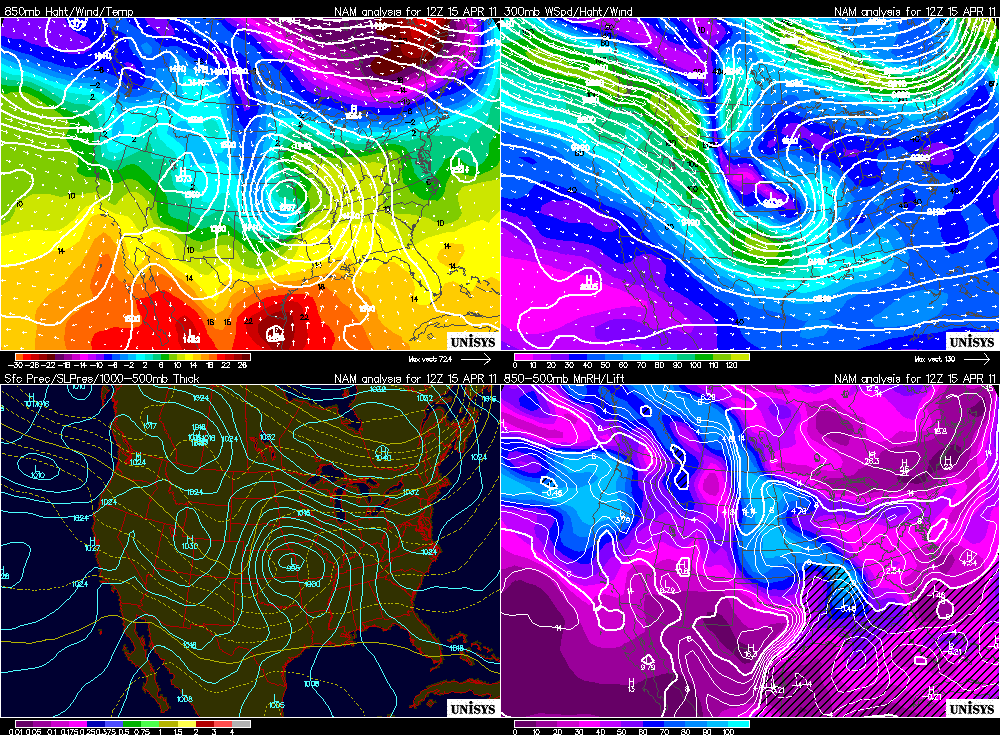
Here are preliminary tornado reports over the last 5 days. Keep in mind these are preliminary, and will take a while to officially be confirmed:Tuesday, April 26: 54 tornado reportsMonday, 25: 44- one tornado may receive a EF-5 rating in Arkansas. Sunday, 24: 13Saturday, 23: 9Friday, 22: 28 That is an ugly stretch of storms. They were spread out across all of the Midwest and South. But that stretch of 5 days does not compare to reports a few days earlier. On April 19th, the SPC had77 reports of tornadoes mainly in Missouri, Indiana, Illinois and Ohio. That was the third-highest total for the month so far. A few days earlier on the 16th, 139 unconfirmed tornado reports across North Carolina and Virginia. And the most reports of tornadoes for April came on the 15th when 146 reports came in from Mississippi and Alabama. In all, 654 reports have been made for the month of April, according to the Storm Prediction Center. Again, they are preliminary and it is possible that not all will be confirmed as tornadoes.Take a look at this map that shows the distribution of tornadoes so far this year (notice one in Oregon! It received an EF-0 rating). Often times, severe wind damage can be confused as tornado damage. It is the job of the NWS to analyze storm damage in person. This process is what gives us tornado ratings. Often people think that the Enhanced Fujita ranking system is based upon wind speeds when it actually is based upon damage. How does this April's reports compare Aprils' past? In 2009, 226 tornadoes were confirmed. The 3 year average for April is 185 tornadoes. So, should all 654 reports be confirmed, that would be more than twice the 3-year average for the month of April! Incredible. What's even more incredible is that the peak tornado season hasn't even started yet! That distinction belongs to May with a 3-year average of 322 tornado reports. May also holds the all-time record for tornado reports of 543 in 2003. What is the possibility of all 654 April reports this year being confirmed? Given the large number of reports, it would be hard to imagine that all of them were tornadoes. But all we have to do is look at January 2011 for evidence to the contrary. There were 10 preliminary reports of tornadoes this January. The actual report of tornadoes by NOAA was 16 (that also stands as the total number of official tornadoes so far this year, but February doesn't have official totals yet). So it is possible that these reports will be confirmed. Along with severe weather comes loss of life. Over the decades of weather reporting and forecasting, deaths resulting from severe weather has improved greatly. More information at the fingertips of forecasters means improved warning systems. But the shear amount of storms this Spring season is starting to take its toll. April 2011 has 43 confirmed deaths from tornadoes. The 3-year average is only 6. So WHY is all this happening? Let's take a look at the charts and find some similarities between April 15, 16, and 19. Here are the charts for the 15th around 5 a.m.
The maps we want to analyze are the two upper maps. The one on the left is the 850mb map. Look towards the Gulf Coast. Notice how warm, moist air is pouring in off the gulf into Louisiana and Mississippi indicated by the warmer colors. That causes instability and uplift in the atmosphere. The map to the right is the 300mb map. This shows the position of the jet stream. A strong, westerly stream is preferred for severe weather. That is exactly what we have. Lots of warm air, plus strong westerly jet is a great recipe for storms. Watch this as it moves east on the 16th. Here is the setup for April 16th around 5 a.m.
Now all the action has swung to the east. Cold stable air is now pouring into Louisiana and Mississippi a day after the severe storms and the warm moist air is now being forced up the eastern Atlantic. This was an interesting situation where the warm Gulf moisture was being sucked up and mixed in with the warm Atlantic moisture off the east coast. The warm air, plus a strong jet stream on the 300mb map that is evident over the Carolinas spawned a tornado outbreak of record proportions in North Carolina. It definitely helped that the storms really were initiated the day before over the south and continued as they migrated towards the east. But another thing that aided these storms the Appalachian Mountains. As air descends down the mountains, it is forced to stretch. Imagine an ice skater that is spinning. As the skater pulls their arms in, they spin faster and faster. This is conservation of momentum. That is what the air is doing as it travels down the back side of the Appalachians. The air is warming, compressing and spins a bit faster in order to conserve energy. A perfect setup for tornadoes. A few days later, it was the Ohio Valley's turn.
Here is the setup for April 19th
Overall, this setup isn't much different than the initial outbreak on the 15th. There is a tighter low over the central part of the country again that is pulling the warm air from the south. The broad cool air stretches east-west along Ohio, Indiana, Illinois. That is our target. A strong jet stream just to the north of those states helps enhance the storms. The main factor though is the tight gradient between the warm and cold air. In the lower left hand map, you see surface pressure plotted. The main feature is that low. The bulge in the isobars protruding eastward is the warm front. It shows up nicely on the 850mb map as well, huh? This system resulted in those 77 tornado reports!
So knowing that April could set a record for confirmed tornadoes, what does that mean for May when historically we see the most tornadoes? We don't know. The broad scale weather pattern is always changing. We can only see 3-5 days out in regards to issuing credible severe weather threats. So in that sense, there is no use in forecasting out any further. In my eyes, it is smart to only look ahead one day at a time. As of today, looking ahead shows a slight break for tomorrow. A break which will be much needed for many as clean up efforts have been hampered by more storms. The actual number of tornadoes will take a while to be confirmed but given what is going on, take solace in the rain and mid-50's.
****UPDATE****
Yesterday's storms that ripped through the South added to what will no doubt become a historic and infamous April. Various reports have the death toll reaching 194 as of 6 a.m. this morning. No doubt that number will rise as the clean up effort begins in earnest this morning. I would assume that there would be potential for an EF-4 or even EF-5 rating out of this outbreak given the reports and videos. There have been 162 reports of tornadoes from yesterday, making it the most so far this year. As I mentioned yesterday, most likely not all will be confirmed as tornadoes and some reports may even be of the same tornado. While watching coverage yesterday, news stations in Birmingham, Alabama caught a twister that may have been on the ground for 45 minuets! It is tough to put this event into words, so I'll let the pictures do the talking.
Tornado caught in Tuscaloosa, Alabama- one of the hardest hit areas- via Crimson Tide Productions:
The battle rages on around most of the country. This is the time of year where complaints start to roll in. Too much rain in Oregon. Too much heat in the Southwest. Too much snow in the Northeast! I have been hearing plenty of them and I am sure you have them too! Here in the Northwest, March left us with plenty of wet weather and April hasn't been too stellar either. Take a look at this map which was used on the Fox 12 Weather Blog (those guys do a really good job over there) that really sums up the wet Spring:
How about the Great Plains? They had a record-breaking winter and now spring and winter are REALLY going at it. The topography of the United States allows for a perfect set up for this battle. Cold air from Canada filters down the east side of the Rockies at the same time warm air pushes up the Midwest from the Gulf of Mexico. With no mountain chains to block either air mass, they clash and the result is awesome but very dangerous and deadly.
Essentially, warm air and cold air don't get along. The result causes instability in the atmosphere and can result in any number of severe weather events. Here is a look at the clashing of air masses on weather maps. These maps reflect a severe weather outbreak from last week that stretched from Minnesota to Michigan.
Note the map in the upper left-hand side. This is the temperature of the air at about 5,000 feet. Notice the warmer air pushing from the south to the north and the contrasting cold air moving down from the north. Check out this radar image from one of the storms that moved through Wisconsin. The National Weather service receives reports of damage from these storms, anything from wind damage to tornado and hail damage. This is a map from the same event: This sort of weather is my dream job! To forecast it. To capture it. To live it! I sit at work and do my best to forecast severe weather across the country each day. The spring is the best time for this across most of the United States. In fact, as I look at the maps today, the Midwest is in store for another round of potentially severe weather Thursday and Friday!
Look at the bulls-eye of low pressure showing up over Nebraska, Oklahoma, Missouri and Arkansas. Notice the warm air and cold air mixing? The black arrows indicate wind direction and speed. Lots of mixing of warm and cold air, so this is an area of concern for severe weather on Thursday and Friday. My thoughts are echoed by the Storm Prediction Center:
Great set-up for the next few days for severe thunderstorms and tornadoes! Gotta love this time of year.
 Here is the 500mb map valid last night for July 4th around 11 a.m. Look at the ridge that covers most of the West and extends all the way into northern Canada! This is a great set up for a nice stretch of warm, sunny conditions! Other maps re-enforce this fact.
 The map above is our 850mb map. We use this map to locate areas of warm air and areas of cold air. We can track their movement with this map. The red contours on the map are isotherms, lines of constant temperature, in degrees Celsius. Temperatures at the 850mb level loosely translate to specific temperatures at the surface. This map, again valid last night (June 27th) shows the conditions for late morning on the 4th. The 15-degree isotherm is just to our east. If we estimate the 850 temp to be about 14 degrees Celsius above Portland, that would translate to an 80-degree day! Plenty of time for it to change, one way or another, but the warm temperature fits the above 500mb map we looked at!
 Here is your surface map for the Fourth of July! Looks awesome! Precipitation is nowhere to be seen. Also not the high pressure system out off the southern Oregon coast. That helps send any sort of wet systems well to our north! Any time we see surface pressure around 1020, that means good things. The 1020 isobar (lines of constant pressure) is right in our neighborhood. Average surface pressure is right around 1013. The higher the pressure, the better the conditions!


