 On to day three of the forecast test. Still a few days out from getting better data for the 30th. Currently I am using just one model (something called "model-riding") but we have to get within 72 hours in order to get a look at multiple models. We are still looking at an ever-changing situation for Sunday. I am see another increase in chance for precipitation on Sunday. It doesn't look like a real big rain event, just some scattered light showers. Let's get into what has changed:
Surface
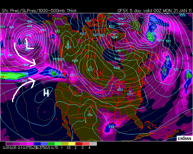
Yesterday the surface model was forecasting some moisture from the south moving into our area. Today that threat has diminished. Off the California-Oregon border, high pressure has built northward. That will interact with a developing low pressure system establishing itself in the Gulf of Alaska. In the Northern Hemisphere, high pressure is associated with a clockwise spinning rotation. Low pressure in the Northern Hemisphere is associated with a counter-clockwise rotation. Look how these two rotations interact with each other. They wind up converging right in our region. That will help send a little disturbance our way.

850mb
The 850mb map re-enforces what we see at the surface. The higher pressure that built northward is surrounded by warmer temperatures. The low pressure that has developed contains cooler temperatures. With the rotation of each system kept in mind, we see that there will be a convergence of warm and cooler air. This is what's called Warm Air Advection, areas where warm air pushes into an area of cool air. The WAA isn't strong but nonetheless it helps that we have a little to enhance uplift and some unstable conditions.


500mb
The first few models that we looked had a prominent ridge over our heads. In today's model, that ridge has flattened out a bit. Remember that shortwave that I talked about the past two days?? It has disappeared from our region. It sagged even further south and merged with a trough that was almost off the map the first few runs. The fall out of this shortwave means that we won't be getting the moisture from the south. That energy falls to Baja California. So where will we get the energy for the moisture??


300mb
Our last map reveals the new source of energy. First off, this map re-enforces the shortwave that moved south. Look at the trough that sags all the way down to Baja California. The shortwave followed this flow. Back in our region, there is nothing that impressive to look at. However, there is a small jet streak to our north. This streak is located over northern Washington and Idaho. The rule of thumb with a jet streak is this: look at the jet streak from behind it as it flows west and split the streak into quadrants (as I have done to the image below). There are two quadrants to take note when looking for weather action. The front left quadrant (known as the left exit quadrant) and back right quadrant (right entrance quadrant). These are areas of PVA, or positive vorticity advection. PVA is associated with areas of uplift, which causes air to rise, cool and condense out often leading to precipitation. Well guess where Portland is in relation to the jet streak. In the right entrance quadrant! That is right where we want to be when looking for some precipitation action. Again, our jet streak is fairly weak. Look at the jet streak out in the Pacific, that is a strong streak associated with that low pressure system up in Alaska.


As you can see, each day brings change. The atmosphere is always changing and it is easy to see why there are so many revisions to a forecast, especially during the winter months! Nonetheless, not many changes have been made to the initial forecast. It helps that this doesn't appear to be a big winter event, too! Back again tomorrow.
No comments:
Post a Comment